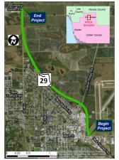
417540-5 SR 29 from CR 846 E to North of New Market Road N
Latest NewsProject Details
Estimated Costs
| Construction Cost: | $56.3 million |
|---|
About
About the Design
History
In 2007 a Project Development and Environment (PD&E) Study was conducted to develop and evaluate alternative concepts for widening approximately 15.6 miles of SR 29 from Oil Well Road to SR 82 from two lanes to four lanes, and to consider potential corridors that could bypass downtown Immokalee.
Early in the PD&E Study process, FDOT conducted a corridor analysis in which four corridors were selected for evaluation within the project study area. The corridor analysis was followed by an alignment analysis, which evaluated 31 alignments within the selected corridors. The next step was to develop alternatives from the recommended alignments. The alternatives were subjected to more detailed analyses, and recommended alternatives were selected. At each phase of the process, a public meeting was conducted to provide an update on the project’s status and to take comments from the public and local agencies regarding the corridors, alignments or alternatives being presented.
With the Federal Highway Administration's approval of the PD&E Study of SR 29 from Oil Well Road to south of SR 82, the next step in the road widening process involves developing the conceptual plan presented at the PD&E public hearing and developing it into a formal set of construction plans that will be used to bid and build the widening of SR 29.
The design project for this 3.35-mile segment of SR 29 from CR 846 E to north of New Market Road N (417540-5-52-01) began in May 2019 and is currently underway. This project is currently funded for construction.
Project Objective
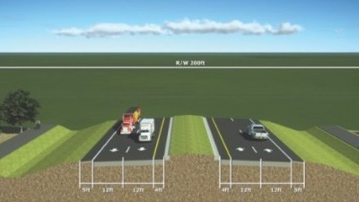
The proposed improvement involves construction of a new alignment of SR 29 as a four-lane divided roadway, to serve as a bypass around the downtown Immokalee area. The design will have four 12-foot travel lanes with curb and gutter on both sides, a 22-foot median, and 12-foot shared use paths on both sides. A design speed of 45 mph will be utilized from CR 846 E to Gopher Ridge Road and design speeds of 50 mph and 55 mph will be utilized from Gopher Ridge Road to north of New Market Road N. The project also includes drainage improvements along the entire length of the corridor.
Proposed Typical Sections
The design from north of the CR 846 intersection to Gopher Ridge Road includes:
• Four-lane divided roadway
• 45 MPH speed limit;
• 12-ft shared use paths on both sides
• Emergency/Pedestrian actuated signal for Immokalee Fire Station on Airport Access Road;
• Maintaining airport, emergency, and park access.
The design from Gopher Ridge Rd to just north of New Market Road N includes:
• Four-lane divided roadway;
• 50-55MPH speed limits; and
• 12-ft shared use paths on both sides
• Signalized intersection at the SR 29/ SR 29 Bypass intersection