455291-1 Florida Heartland Regional Trail - Collier County
Website for Entire Project: https://floridaheartlandregionaltrail.com/
Project Details
| Work Type: | Bike Path |
|---|---|
| Phase: | Planning |
| Limits: | The Florida Heartland Regional Trail – Collier County project collectively captures three specific trail planning corridors including the Paradise Coast Trail (PCT) consisting of 75.2 miles, the Marco Island Loop for 18.6 miles, and the State Road (SR) 29 Trail consisting of 42.4 miles. |
| Length: | 136.2 miles |
| City: | |
| County: | |
| Road: | |
| Start of Current Phase: | Mid 2025 |
| Est. Completion of Current Phase: | Mid 2027 |
About
In 2024, FDOT completed the Collier to Polk Trail Master Plan to evaluate a paved, multiuse trail for bicyclists and pedestrians from Collier County to Polk County. The Master Plan included preliminary routing alternatives and associated recommendations to develop the project as a regionally significant trail within the Florida Shared-Use Non-motorized (SUN) Trail Network. The Master Plan set the stage to conduct feasibility studies for what is now called the Florida Heartland Regional Trail.
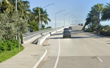
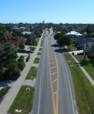
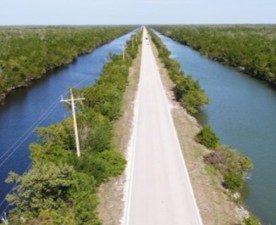
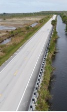
The Master Plan resulted in a defined trail corridor within Collier County that includes three trail segments: the 75.2-mile Paradise Coast Trail (PCT), the 18.6-mile Marco Island Loop Trail, and 42.4 miles of trail along State Road (S.R.) 29 within FDOT right-of-way. The Paradise Coast Trail primarily utilizes existing roadway corridors to connect Immokalee to Collier-Seminole State Park in southern Collier County. The north-south component of the PCT includes the existing Rich King Memorial Greenway and portions of existing trail along United States (U.S.) 41 (Tamiami Trail). The east-west component of the PCT links Baker Park and Gordon River Greenway with the Paradise Coast Sports Complex and continues east to Immokalee where it eventually connects to the S.R. 29 Trail segment. The S.R. 29 Trail segment extends from Everglades City to the Collier/Hendry County line. The Marco Island Loop Trail extends along S.R. 951 (Collier Boulevard) from Judge Jolley Bridge to U.S. 41 and County Road (C.R.) 92 (San Marco Road) from Goodland Road to U.S. 41.
Explore the proposed trail alignments through Collier County
The purpose of this feasibility study is to further evaluate the trail corridor to establish the SUN Trail network for the FHRT in Collier County.
Public Involvement
Public involvement is an integral part of the feasibility study process. FDOT will engage interested parties in the study process and there will be opportunities for public comment, including a public information meeting. You may also submit comments or questions about this project at any time during the study, by using the "Send a comment" button to the right.
If you are interested in being added to the mailing list to receive study information, please use the "Send a comment button" to provide your information to the project team.
FAQs
What is a regionally significant trail?
The Florida Heartland Regional Trail has been identified and prioritized as a regionally significant trail by the Florida Greenways and Trails Council [Section 260.0142(4)(c), FS]. That means it is recognized for its potential to:
- Cross multiple counties
- Attract national and international visitors
- Provide opportunities for economic and ecotourism development
- Showcase the value of wildlife areas, ecology, and natural resources
- Serve as a main corridor for critical links and trail connectedness
Why are multiple feasibility studies being conducted?
Because of the Florida Heartland Regional Trail’s extensive length, separate feasibility studies are being conducted in each of the counties that are part of the trail planning area: Collier, Hendry, Glades, Highlands, Hardee, and Polk. While the feasibility studies will follow their own schedules, they are all expected to be completed in Spring 2027.
What is a feasibility study?
A feasibility study considers potential social, economic, and environmental effects, as well as constructability and costs, to determine project viability. The study helps FDOT determine how the project will move forward to future phases. The starting point for the Florida Heartland Regional Trail’s feasibility studies will be the Collier to Polk Trail Master Plan’s preliminary routing alternatives.
Data Collection
The first major work effort is the collection of all available data pertaining to the study corridor including existing and planned infrastructure, existing and future land uses, drainage patterns, and environmental resources.
Public Kickoff Newsletter
A public kickoff newsletter is mailed to introduce the project to the public and provide an opportunity to view and comment on the project’s need and objectives.
Feasibility Study Report
The Feasibility Study Report will document results of the public outreach efforts; development and evaluation of planning level trail alignments; and potential issues or impacts that could eliminate potential alignments from further consideration.