455295-1 Florida Heartland Regional Trail - Glades County
Project Details
Estimated Costs
| Construction Cost: | $TBD |
|---|
About
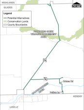
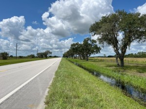
The Feasibility Study for the Glades County segment of the Florida Heartland Regional Trail will evaluate the feasibility of constructing an approximately 31-mile-long multi-use trail along SR 29, US 27, SR 78, Ortona Road, and Dalton Lane in Glades County. Currently, there are no designated bicycle lanes or sidewalks present on either side of the roadways with the exception of 5-foot wide sidewalk along Ortona Road. If completed, the project would provide a 12-footwide multi-use trail allowing bicyclists and pedestrians to travel safely along various corridors while providing regional connectivity.
The preliminary route alternatives, or alignments, will be evaluated to determine potential social, cultural, natural, and physical environmental impacts and benefits, engineering constraints, and safety enhancements. The proposed trail passes through Palmdale providing potential connection to the Fisheating Creek Wildlife Management Area. In addition, the study will evaluate access to the Ortona Lock South Campground, Ortona Locks North Day Use Area Public Boat Ramp, and Ortona Indian Mounds Park.
Please click the link below to visit the Florida Heartland Regional Trail website for more information.
Public Involvement
Public involvement is an integral part of the Feasibility Study process. FDOT will engage interested parties in the study process and there will be opportunities for public comment, including a public information meeting. You may also submit comments or questions about this project at any time during the study, by using the "Send a comment" button to the right.
If you are interested in being added to the mailing list to receive study information, please use the "Send a comment button" to provide your information to the project team.
FAQs
What is a regionally significant trail?
The Florida Heartland Regional Trail has been identified and prioritized as a regionally significant trail by the Florida Greenways and Trails Council [Section 260.0142(4)(c), FS]. That means it is recognized for its potential to:
- Cross multiple counties
- Attract national and international visitors
- Provide opportunities for economic and ecotourism development
- Showcase the value of wildlife areas, ecology, and natural resources
- Serve as a main corridor for critical links and trail connectedness
Why are multiple feasibility studies being conducted?
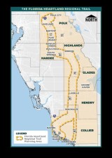
Because of the project’s extensive length, feasibility studies are being conducted for each county that is part of the Florida Heartland Regional Trail planning area: Collier, Hendry, Glades, Highlands, Hardee, and Polk (see map). Each study will follow its own schedule to evaluate the Master Plan’s preliminary alternatives, assess environmental impacts, and solicit public input. A “no-build” alternative will also be considered which assumes that the trail will not be developed. For general information, visit the project website at FloridaHeartlandRegionalTrail.com.
What is a Feasibility Study?
A Feasibility Study considers potential social, economic, and environmental effects, as well as constructability and costs, to determine project viability. The study helps FDOT determine how the project will move forward to future phases. The starting point for the Florida Heartland Regional Trail’s feasibility studies will be the Collier to Polk Trail Master Plan’s preliminary routing alternatives. The basic activities of the Feasibility Study include:
Data Collection
The first major work effort is the collection of all available data pertaining to the study corridor including existing and planned infrastructure, existing and future land uses, drainage patterns, and environmental resources.
Alignment Development and Analysis
Once data collection is completed, various alignments are developed that meet the purpose and need of the project. These alignments are evaluated to identify potential impacts, or constraints on the social, economic, natural, physical, and cultural environments. The evaluation also includes the development of preliminary cost estimates and determination of the need for additional right-of-way for improvements, if applicable and public outreach will also be completed.
Feasibility Report
The Feasibility Study report will document results of public outreach efforts; development and evaluation of alignments; and the feasible Recommended Alignments that can proceed to the next phase for in depth analysis.